Interactive Route Maps and GPX File Downloads
One of the first jobs you'll need to do when planning a race is to create a route map and make it available on your own website along with a downloadable GPX file for racers' mobile devices
Forget static map images, they may look nice but they're not as helpful as an interactive version with useful distance or elevation information and they're no use at all for the growing number of racers with mobile devices looking to navigate the route or monitor and measure their performance on race day.
Avoid third party map sites they are almost certainly going to charge you or be monetised with distracting ads that will divert your participant's attention away from your race content or entice them to click away from your event landing page.
The Solution is Mapping and More with Eventrac
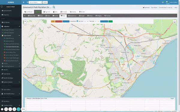
Eventrac has all the inbuilt tools you need to create and share interactive race maps and offer downloadable files for racers' mobile devices and offers features such as:
-
Automatic embedding, within your own brand entry landing pages or as a widget on your own or any other website page
-
Link sharing, so you can promote your course map within your operational and marketing emails and in your social media posts
-
Downloadable files for participants’ mobile devices, in tcx, txt, gpx, kml file types
-
Course information showing total distance and elevation gain/loss
-
Elevation graph profile with gradient views
-
Zoomable satellite and map viewing options